After New York, we went home to recover and in late October we headed to the Caribbean to rejoin the ship. We invited good friends Rob and Rachel to join us from Seattle.
We stopped for a couple of days in the Dominican Republic. This is only our second time there, but we continue to be impressed with their progress. It’s so sad to see the disparity between the DR and Haiti, their island neighbor. We stopped in Casa de Campo, a high-end resort area noted for its villas, beaches, and golf courses. We got to play Pete Dye’s “Teeth of the Dog” which is always among the top 50 in the global rankings. It was beautiful and very playable – not like some courses that pride themselves on destroying your pride.


From there we sailed to a couple of small islands for “beach days” (our favorite), and then down to Cartagena, Columbia – one of the early Caribbean settlements. A great old town, with plenty to see, do, and eat. Rob, Rach, and Debra were glad to have me along with my scruffy beard and black eyes – they felt like they had a bodyguard. We also joined the festivities on Halloween on board, with Rachel acting as our make-up artist.


Finally, we headed to Panama for the crossing of the canal. Time for your test questions:
- When you sail through the canal from the Atlantic (Caribbean) to the Pacific, in which direction do you go?
- We all know the canal has numerous locks to change water levels (at the beginning, 3 locks take you up 85 feet, and at the end, 3 locks lower you to the Pacific. Since “sea level” is about the same on both sides, why didn’t they just dig a simple trench like the Suez Canal?
Think about it…
I often wondered why they needed locks, but never bothered to look it up. A simple trench was one of the options. In fact, in 1882 Ferdinand de Lesseps, the French architect of the Suez Canal started a company to do just that. But Panama is volcanic rock, not sand – it has mountains, not a flat desert – and the malaria and yellow fever devastated his crew. They gave up after 7 years.
After the sinking of The Maine near Cuba during the Spanish-American war, it took 66 days for the U.S. to send a warship from San Francisco and around South America to respond. Teddy Roosevelt, who was Assistant Secretary of the Navy at the time, became passionate about building a canal when he became President.
The U.S. design first dammed a large river flowing out of the mountains. This created a huge lake (Gatun) that covered a good portion of the 50 mile isthmus. It is about 85 feet higher than the oceans, but created a ready-made sailing path without needing to dig. The elevation also meant the cut through the continental divide could be 85 feet less difficult to forge. So the dam/lake system reduced the work dramatically, but required a series of locks to elevate the ship from ocean level to cross. Brilliant.
As for direction, going from the Atlantic to the Pacific is generally southeast (see map below). Probably a good bar bet.


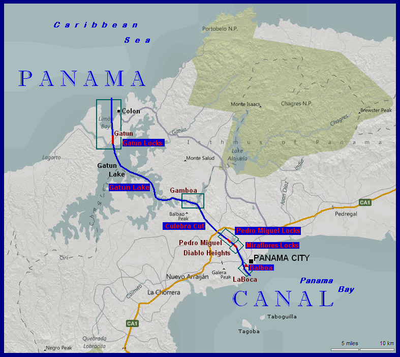
The whole crossing takes about 8 hours. Ships are charged by the pound, large ships pay between $100,000 and $350,000. But it saves 8,000 miles from rounding South America.
I took a time-lapse video of the entry and exit locks you might enjoy (30 seconds each).

Dave glad to see you are back to work-you may want to stick with golf and “work” and drop soccer. At least play midfield
I really liked the Panama Canal video- I have read a bit about the canal however you. has perked my interest I am going to read McCullough’s book on it
Sure looks like you guys are having a good time
Ron
LikeLike
The time lapse video helps but I’m still confused. I think I need to Google that one.
LikeLiked by 1 person